This project proposes a networked tsunami evacuation shelter system for the Japanese city of Kochi-shi, in Kochi prefecture of Shikoku Island. The primary goal is to design an accessible and robust evacuation shelter that provides a safe haven during a tsunami event whose severity and power cannot be predicted. This is achieved by harnessing the destructive natural forces rather than trying to resist them with over-engineered structures. Secondary goals include integration of the shelter structures into normal daily life by layering civic uses that function as urban amenities, such as a public meeting and gathering space, and a community center.
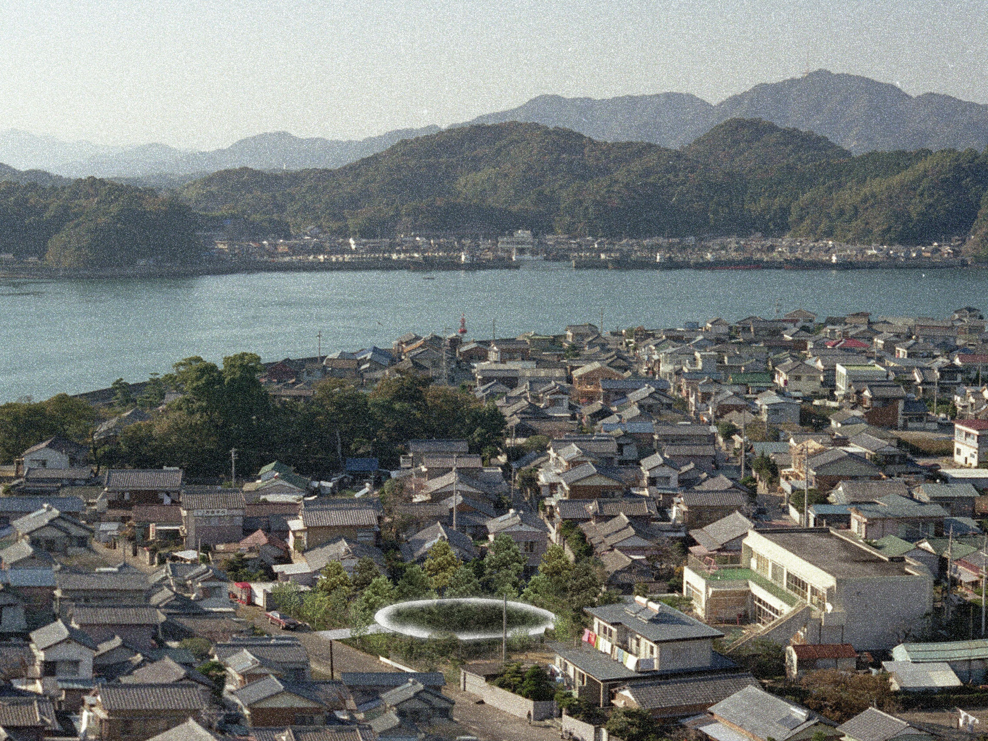
Figure 1: Kochi in relation to historic earthquake epicenters off of the eastern coast of Japan, red dot indicates area of predicted imminent mega-quake
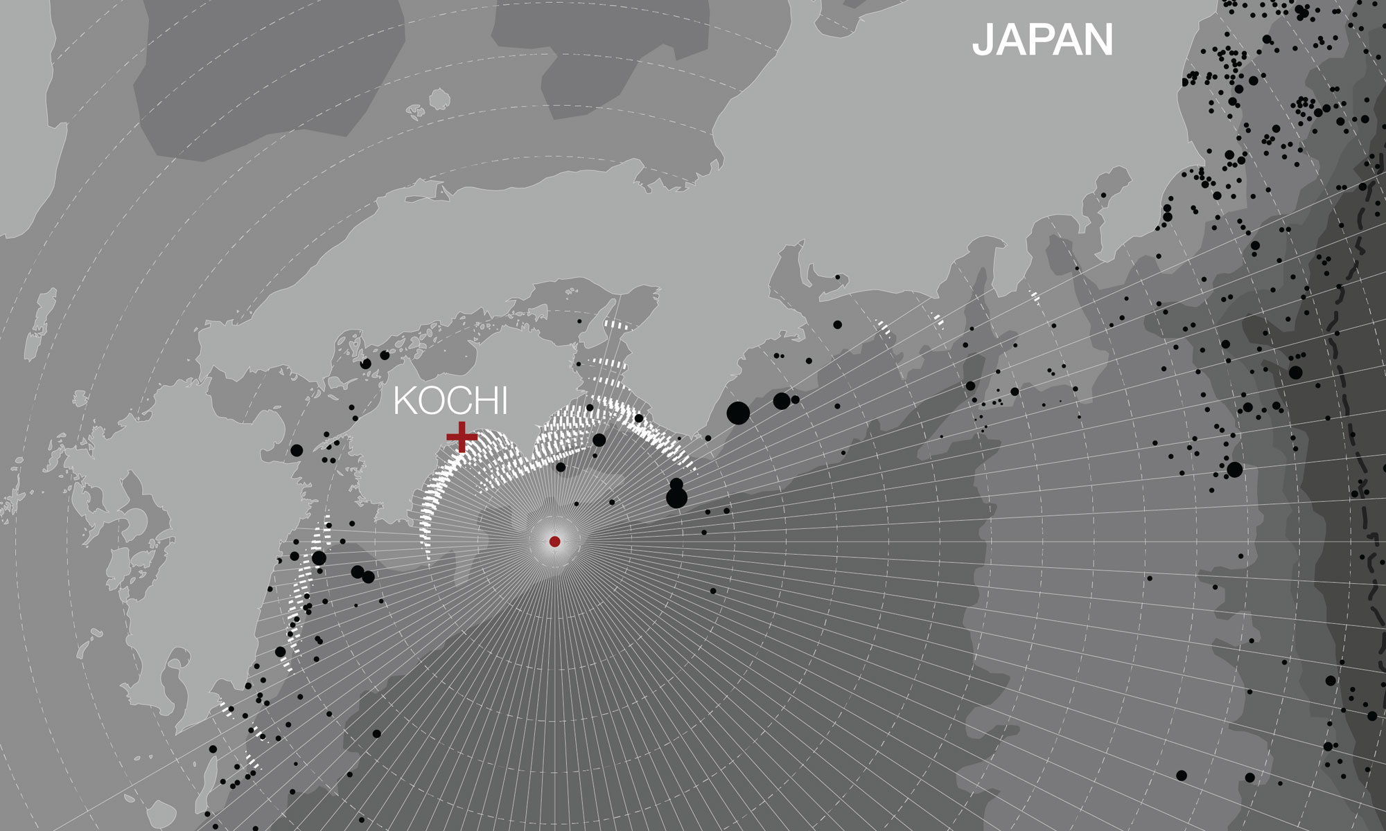
Figure 2: Kochi in relation to projection of potential tsunami waves, shape of coastline shows possible focusing of wave intensity towards city center
Tsunamis are generated by large displacements of the benthic floor, caused by subsurface landslides, volcanic activity or earthquakes. When a tectonic plate slips under a neighboring plate, a subduction earthquake is triggered, which is particularly effective in producing strong tsunamis. The island of Shikoku sits at the convergence of several active plates: Pacific, Philippine and the Amur Plates. The annual subduction rate for this group of plates is among the highest in the world, with a velocity of 102mm per year occurring along the Nankai trough, just a few hundred kilometers east of Shikoku. Tsunamis have historically caused catastrophic damage, with massive loss of human life and property due to the inundation of seawater onto land at high velocity.
The city of Kochi is considered for two important reasons: its geographic location facing the Pacific Ocean and its high percentage of elderly inhabitants. The city is located on the eastern shore of Shikoku Island, within seismic zone 5, with a direct exposure to the Pacific Ocean and the origin of some of the largest historic earthquakes (Figure 1). The threat of a powerful tsunami is imminent, and the geometry of the larger island coastline can act as a magnifier focusing the energy of the large waves towards the city (Figure 2). The extent of vertical run-up of seawater depends on near-shore bathymetry, beach profile, land topography and the frequency and velocity of tsunami waves (Cho, Lakshumanan, Choi, Ha: 2008). Thus, tsunami inundation patterns will vary according to the specific topography of a given area.
The city has the benefit of being set back from the waterline, with a high ridge of hills providing a formidable buffer. However, there is a wide opening between the hills which would allow a large volume of water to make its way to the city center. A less developed portion of the city extends out to the waterline, with industrial, agricultural and residential areas fully exposed to the waves.
Given the potential short warning of an incoming tsunami, a major concern is the welfare of mobility impaired residents, such as young children and the elderly. Kochi’s population is aging rapidly, with more than 27% over the age of 65 (Statistics Bureau, Japan: 2012). In the event of a tsunami, the city’s population would need to seek shelter (higher ground) rapidly in order to escape the deadly rush of water.
The proposed tsunami shelter system attempts to address the above factors by creating a network of shelters throughout the city, which are set apart based on the average walking speed of an older person. The open exposure of the coastal portion of Kochi-shi, necessitates a tighter spacing of shelters to allow for a quicker travel time to each shelter (Figure 3). Given the potential of a nearby epicenter, one has to assume extremely short travel times. Since tsunami waves typically flow inland perpendicular to the shore, we can assume longer travel times as one moves uphill and away from the coastline. The network responds by loosening, with fewer shelters spaced further apart. Similarly, the typology of the shelter needs to be adjusted based on its position relative to the coastline. Shelters located within the immediate inundation zone will be subject to different forces than those sited inland or uphill.
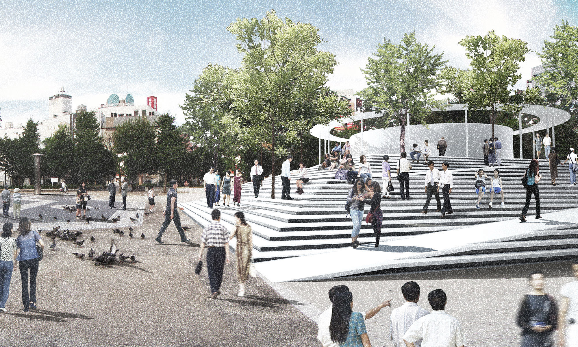
Large scale tsunami events have historically been forecast to occur in roughly 100 year spans, so the design for an evacuation shelter should take into account the probability that it will be disused for long periods of time. The proposed schemes incorporate a civic component, so that they can be used in other ways than merely an evacuation vessel. The inland version is pyramid shaped with an open stair and ramps (Figure 4) on each side that serves multiple functions: a public meeting and gathering space (Figure 8), an enclosure for a community center, and a support for the float away shelter component. During an event, the steps and ramps provide a means for vertical escape from the powerful horizontal rush of seawater, while the float away evacuation vessel serves as a safe last resort in case the waters rise beyond historic levels. The vessel would be released by the natural buoyancy force applied by rising water. It would ride on top of the powerful stream of water rather than trying to resist it (Figure 5). Its circular form allows the vessel to roll around obstacles minimizing the chance that it would become trapped between obstructions. The curved hull of the vessel enables it to be lifted and settled without overturning by multiple waves, which are common during tsunami events. These shelters would be loose, floating freely in the water, or fixed on pylons which would limit their horizontal and vertical displacement. The latter is proposed for zones that are furthest away from the coast and least susceptible to inundation.
Coastal shelters are proposed as fixed sub-grade structures (Figures 6,9) with access limited to the side facing away from the ocean. Their underground location allows for the incoming wall of water to pass overhead without absorbing any of its energy (Figure 7). The underground shelters pose their own set of problems, such as ensuring a tight seal within a given period of time, while people may still be trying to get inside. There is also the potential for shelter entrances to be blocked by debris which would slow down relief efforts after the waves have returned to normal. An additional challenge is ensuring a sufficient supply of oxygen in case the shelter should be submerged for an extended period of time.
The driving philosophy behind this evacuation network proposal is that human survival depends on adaptability and flexibility. Rather than trying to fight against the power of natural forces by erecting ever stronger or higher walls, we suggest instead that we absorb the might of nature, by ducking under it, or floating on top of it. Our continued survival depends on a willingness to adapt to nature’s strength, fostering an ability to harness its strength rather than relying on increasingly monumental mega-structures which have been historically proven to fail.
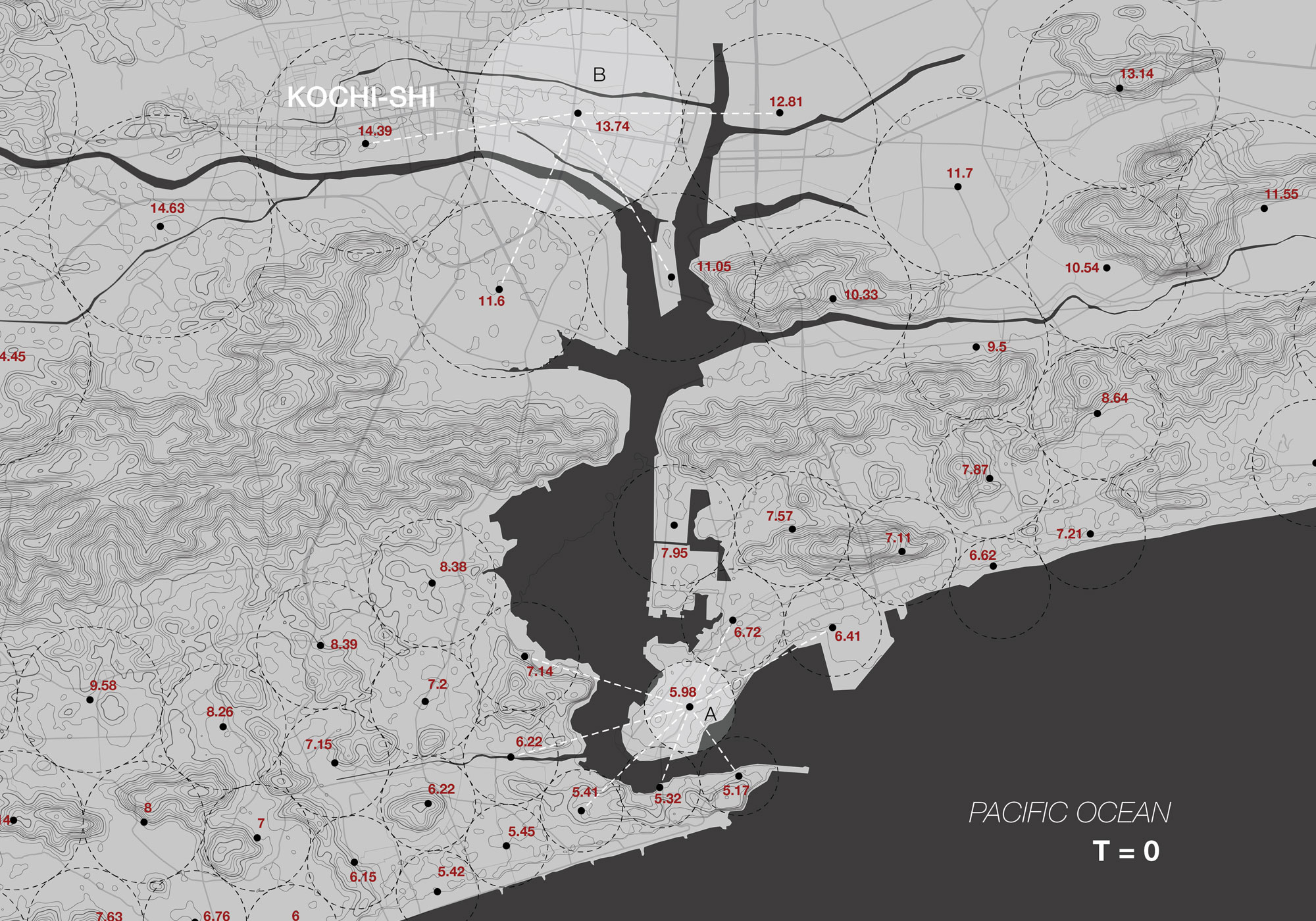

Figure 3: Map of evacuation shelter network
(a) Density adjusted based on distance to shoreline, red numbers indicate travel time in minutes from perimeter of shelter zone to central evacuation point. Shelter area ‘A’ is within the coastal zone typified by sub-grade shelters, while area ‘B’ is within an inland zone with a stepped pyramid and float-away shelter
typology
(b) Map showing potential tsunami inundation levels given the existing topography and historical records. Existing steep topography obviates the need for
shelters in hilly areas
 Location: Kochi-shi, Shikoku, Japan
Date: March 2013
Project Team: Ostap Rudakevych, Masayuki Sono, Tomoko Matsushita, Lapshan Fong